


Sjøisutbredelse (SIE indeks)
Utbredelsen av sjøis overvåkes av flere institusjoner. Sea Ice Extent (SIE) indeks har siden 1979 fuglt sjøisen i polare strøk. Den gir daglig mål på utbredelse og konsentrasjon av is basert på bilder tatt av Nimbus 7-satellitten, med en oppløsning på 25×25 km.
Arealet av is f.eks. beregnes ved å summere arealet av alle 25x25km ruter som har minst 15% sjøis. Arealindeksen viser dagens areal med sjøis sammen med 30-års medianverdien for den dagen (dvs. den typiske utbredelsen isen hadde mellom 1981-2010). Siden 1979 er sjøisens omfang vinterstid i Arktis redusert med omlag 3 prosent per tiår.
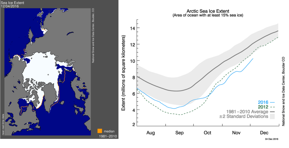
Utbredelse av sjøis (SIE indeks) i Arktis. Kilde: www.nsidc.org
 This project (EDU-ARCTIC) has received funding from the European Union’s Horizon 2020 research and innovation programme under grant agreement No 710240. The content of the website is the sole responsibility of the Consortium and it does not represent the opinion of the European Commission, and the Commission is not responsible for any use that might be made of information contained.