


Indeksi i shtrirjes se Detit dhe i Akullit (SIE)
Indeksi i shkallës së shtrirjes së së detit (SIE) [mln km2] jep një vështrim të shpejtë mbi ndryshimet në akullin e detit në Arktik. Ai jep shkallën dhe përqendrimin e përditshëm të vazhdueshëm të përpunuar të akullit nga imazhet e marra nga sateliti Nimbus 7 që nga viti 1979. Vlerat e indeksit SIE llogariten duke përmbledhur sipërfaqen e të gjitha qelizave të rrjetit 25x25km me përqendrim akulli më të madh prej 15% ose më shumë.
Indeksi ditor tregon shkallën e akullit me një përshkrim të shkallës tipike të ditë bazuar në një mesatare 30-vjeçare (1981-2010). Që nga viti 1979 dimri i akullit të detit në Arktik ka rënë rreth 3 për qind në dekadë.
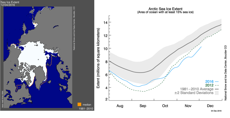
Sea Ice Extent in the Arctic, source: www.nsidc.org
![]()
 This project (EDU-ARCTIC) has received funding from the European Union’s Horizon 2020 research and innovation programme under grant agreement No 710240. The content of the website is the sole responsibility of the Consortium and it does not represent the opinion of the European Commission, and the Commission is not responsible for any use that might be made of information contained.